does anyone have typed, or mapped routes they wouldnt mind sharing, i heard there is one around lake apopka, i have already hit one part of that stretch, binion road is sick 5.5miles 15-20 turns w/ str8s enough to hit at least 130...any help would be great id like to go for a good run on sunday
__________________
Just picked up my GTI May 31st, love driving, workin on cars(simple stuff so far) and yeah....
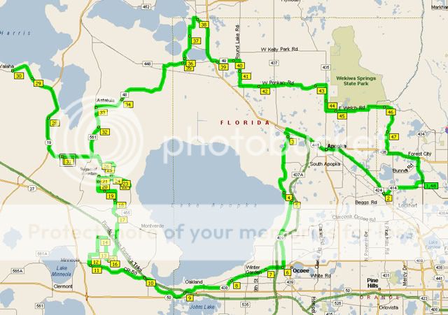
There are so many roads up there. I was going to try to make a map on mapquest, but ten minutes into it I gave up.
I would just say get a good map of lake county and go exploring, that is half the fun. Bring a highlighter and mark the roads you like. Things to look for, roads that run along lakes that are only slightly curved on the map, those tend to be the twistyest.
But stick around the mt verde, to astalula/howey in the hills, lake minnehaha/minneola and east lake apopka area...but there are more in the wekiva springs bassion, Mt Plymouth and such. So the more driving you do, the more roads you will find. It is easy to spend a day out there and never see the same road twice.
__________________
Faster, faster, faster, until the thrill of speed overcomes the fear of death...
Hunter Thompson
yeah, i like the lake apopka area...and havent had time to go to howey in the hills yet, my family owns a place at mission inn, so ill have to go out there, my buddy dan says he has an old cftc route that he is typing up, so once i get it ill post it and see if yall wanna go for a run, supposedly its like 2hrs...
__________________
Just picked up my GTI May 31st, love driving, workin on cars(simple stuff so far) and yeah....
I just found this on my computer... I got it from this board, but it is missing some of my favorite roads on it, so I will try to make my own copy here during the week, but this will get you started. Like 7th Street from Hwy 50 through Montverde is an awesome scenic road, and its not on this map, but like I said, its a start.
-- Edited by Raoul Duke at 19:38, 2006-09-09
__________________
Faster, faster, faster, until the thrill of speed overcomes the fear of death...
Hunter Thompson
dude thats awesome, gonna print it and try some tomorrow, and its prolyl the same one my friend is typiing up so having a map, and then the street names and distances will be perfect!!!
__________________
Just picked up my GTI May 31st, love driving, workin on cars(simple stuff so far) and yeah....
Here is a partial route, its pretty close to complete, but i ran this section the other day, it was about 50 miles, and some awesome roads, lots of intense turns, changes in elevation :)...as soon as i get it finished ill post it back up, dan from my crew is typing it up and im going out and adding the mileage between each section onto it, and as soon as i can ill get a map of it, even tho it seems very close to what is on here
CFTC Road Tour
1. Start out at intersection of Maitland Blvd and 434 heading west on Maitland Blvd.
2. Turn Right on to SR 441 (Orange Blossom Trail)
3. Stay in the left lane as you approach Apopka, pass through Downtown Apopka, and Pass 429 Expressway.
4. Turn Left on Orange Ave (437 Drive), Veer Right following 437 5.5 miles
5. Turn Right on Ocoee Apopka Rd. 2.5 miles
6. Turn Right on Fullers Cross Road 3.0 miles
7. Turn Right on 438 (Plant Road) Continue on 438 (West Plant St.), crossing a bike path, straight through a flashing red light 6.0 miles
8. Turn Right on 91 (old 50), if you reach 50 (Colonial) youve gone too far. Old 50 turns into North 455 6.0 miles
9. North 455 Turns Left 2.7 miles
10. Turn Left on 561A 3.3 miles
11. Turn Left on 561 South towards SR 27 .5 mile
12. Turn Left onto SR 27 1.1 miles
13. Turn Left on North Grassy Lake Road, while going uphill after the lake. 1.0 mile
14. Follow Grassy Lake Road 1.5 miles
15. Turn Left on 561A (yes you were just on this road 10 min ago) 1.1 miles
16. Turn Right on SR 561 North 2.0 miles
17. Turn right on Sugar Loaf Mountain Road, Follow road to left 2.9 miles
18. Turn Left on 561A (yes again) .7 miles
19. Turn Left on 455 West 4.5 miles
20. Veer Right before stop sign onto SR 561 6.7 miles
21. Turn Right on 448 East
__________________
Just picked up my GTI May 31st, love driving, workin on cars(simple stuff so far) and yeah....